Curo cable car, simple clanger or huge cock up?

I’ve added a section about the Curo cable car plan that flew across the sky between 2015 and 2017.

Curo were starting the development of Mulberry Park and having some ‘issues’ with their Foxhill master plan – which was mentioned in last month’s blog ‘Black hats or blunderers‘. 

The Curo cable car plan was abandoned after negative feedback during the consultation process. What I find interesting is why it was put forward? Did Curo really believe that it would receive planning permission in Bath’s World Heritage Site?

Curo are members of the World Heritage Site steering group which also includes:

The World Heritage Site steering group  is involved with producing the Bath World Heritage Site Management Plan.

A quick review of this would have shown the obstacles that the Curo cable car plan would have faced in getting any planning approval. Presumably why they said they intended to bypass the usual planning system and go straight to the Secretary of State for Transport.

Even that, one suspects, would have been a challenge. As the Bath World Heritage Site Management Plan makes clear:

"Government guidance on protecting the Historic Environment and World Heritage is set out in National Planning Policy Framework and Circular 07/09. Policies to protect, promote, conserve and enhance World Heritage properties, their settings and buffer zones are also found in statutory planning documents. The Bath and North East Somerset Local Plan contains a core policy according to which the development which would harm the qualities justifying the inscription of the World Heritage property, or its setting, will not be permitted. The protection of the surrounding landscape of the property has been strengthened by adoption of a Supplementary Planning Document, and negotiations are progressing with regard to transferring the management of key areas of land from the Bath and North East Somerset Council to the National Trust."

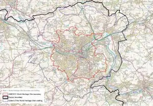
Further reading would have shown:

"The site boundary is the municipal boundary of the city. This covers an area of approximately 29 square km. As noted in chapter 1, Bath is exceptional in this respect as the World Heritage inscription in almost every other city worldwide covers only a part of the urban area and not the entire settlement. Venice and its lagoon is the closest European comparator.

The property was inscribed in 1987 without a boundary map, which was not uncommon at that time. The description of the ‘City of Bath’ was taken to mean that the boundary encompassed the entire city and it was managed accordingly. This boundary was subsequently confirmed by letter (dated 17 October 2005) from the UNESCO World Heritage Centre."

and:

"Bath remains a compact city, contained largely within the hollow in the hills as previously described. The city does not have significant ‘urban sprawl’ and high quality built development directly adjoins high quality landscape at the urban edge. The skyline is predominantly characterised by trees or open pasture. The green hillsides provide a backdrop to the urban area and are visible from most of the city centre. Bath is well provided for in terms of parks and open spaces, with the River Avon cutting through the city centre providing natural beauty and sense of calm. All of the above contribute to an impression that the city is smaller than it actually is."

and: 

"The Green Setting of the City in a Hollow in the Hills

42. The compact and sustainable form of the city contained within a hollow of the hills
43. The distinct pattern of settlements, Georgian houses and villas in the setting of the site, reflecting the layout and function of the Georgian city
44. Green, undeveloped hillsides within and surrounding the city
45. Trees, tree belts and woodlands predominantly on the skyline, lining the river and canal, and within parkland and gardens
46. Open agricultural landscape around the city edges, in particular grazing and land uses which reflect those carried out in the Georgian period
47. Fingers of green countryside which stretch right into the city"

as well as various maps: 

world heritage site extent 300x209
World Heritage Site extent
green belt 300x205
Green belt
conservation area 300x205
Conservation area

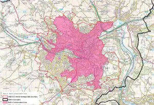
So, why was the Curo cable care plan put forward? It would seem that it was most unlikely to get planning permission – unless there’s something I don’t know about.

Related Images:

Sublime world heritage city of Bath 1700 – 1764

In looking at the history of Combe Down one, inevitably, has to look at the history of Bath 1700 – 1764.

Bath today is very well known, a UNESCO World Heritage site known for its natural hot springs and 18th century Georgian architecture.

TripAdvisor describes it thus:

“Known for its restorative wonders, Bath was once the home of Jane Austen. Sure, you could attempt to conjure up this elegant city by reading Pride and Prejudice in your tub, but as Bath has a lot more history than your bathroom (we assume, anyway) you’d be missing out. A stroll through Bath is like visiting an open-air museum, with roughly 5,000 buildings in the city drawing notice for their architectural merit. After your stroll, soak in the natural hot waters of the Thermae Bath Spa, once a favourite of the Celts and Romans.”

However, it was not always like this. Before the ambitions of John Wood, the Elder (1704-1754) and Ralph Allen (1693-1764) to change the medieval city of Bath into one of the world’s most beautiful cities combining Palladian architecture and landscape harmoniously William Stukeley (1687 – 1765) described Bath, in Itinerarium curiosum; or, An account of the antiquities, and remarkable curiosities in nature or art, observed in travels through Great Britain: Volume 1, so: “The small compass of the city has made the inhabitants crowd up the streets to an unseemly and inconvenient narrowness: it is handsomely built, mostly of new stone, which is very white and good; a disgrace to the architects they have there”.

He also includes a map which is shown below.

map of bath from page 339 of itinerarium curiosum
Map of Bath from page 339 of Itinerarium Curiosum

Of course, Bath had first been a Roman city and after they left was probably both in the hands of the Romano British and the Anglo Saxons until the town became Saxon controlled after the Battle of Deorham in 577.

Bath became a religious centre in 675 when a convent was established and later a monastery, the church of which grew to become Bath Abbey.

After the Norman conquest Bath remained a religious centre with the Abbey becoming the seat of the Bishop in 1157 which was confirmed by a Charter in 1256 from Henry II.

During this period Bath also became a centre of the wool trade and became famous for broadcloth.

Bath Abbey still dominated the town and its development until the dissolution of the monasteries under Henry VIII with Bath being dissolved in 1539.

In 1552 a Charter granted the Mayor and citizens of Bath all property previously owned by the Priory in the city. 

Elizabeth I authorized a nationwide collection over seven years to pay for reroofing and reglazing Bath Abbey in 1573 and also decreed that the Abbey should become the Parish Church of the City, causing the closure of all the other churches within the city boundary and thus Bath has no medieval churches.

Elizabeth I also granted the Charter of Incorporation in 1590 so that Bath became a city.

letter from bath from the derby mercury friday 15 february 1754
Letter from Bath – from the Derby Mercury, Friday 15 February 1754

The loss of the monastery and the decline of the wool trade meant that Bath had to find another way to earn its living and tourism seemed to be something the city could do by using its Roman Baths’ heritage and the thermal springs.

The King’s Bath was improved in 1578 and 1624.

The New Bath was built in 1576 to provide better facilities and then renamed Queen’s Bath after Queen Anne of Denmark (wife of James I) visited in 1613 and 1615.

Though times were not always good, especially during the Civil War when the city was looted royal patronage continued to increase the reputation of the city. Charles II brought his wife, Catherine of Braganza in the hoping that this would produce his first legitimate heir.

Mary of Modena, wife of James II, visited Bath in 1687 needing an heir to the throne, and following her visit gave birth to a son – The Old Pretender.

During all this time, Bath never had a population greater than 3,000 and was surrounded by it’s medieval city walls. (There’s a walk that allows you to see them). The population of Bath was to rise to 28,000 by 1801 and 57,000 by 1831.

Ralph Allen became postmaster in Bath in 1712.

By 1726 his contract with the Post Office to run the cross and bye posts for the country had given him the contacts, confidence and cash to acquire the quarries on Combe Down, probably having seen John Wood, the Elder’s plans of 1725 for Bath which developed the town outside the existing city walls and their constrictions and restrictions.

Over the next 40 years the stone from Ralph Allen’s quarries on Combe Down and Wood’s developments such as St John’s Hospital (1727–28), Queen Square (1728–36), Prior Park (1734–41), The Royal Mineral Water Hospital (1738–42), North Parade (1740), South Parade (1743–48) and The Circus (1754–68) transformed Bath from the medieval to a modern and beautiful city.

map of bath 1780
Map of Bath, 1780

Related Images: