In another tenuous coincidence I have discovered that Benjamin Wingrove (1773 – 1840), who has his own page on this site, and was an attorney, land speculator, agriculturalist and road builder is the 1st cousin 1x removed of the wife of the husband of the 7th great-aunt of our son-in-law. I said it was tenuous!
The Wingroves were a family based in North Bradley until Benjamin Wingrove (1693-1768) moved to Bath He married Ann Pitman (1703 – 1796) in 1730. They had nine children in 16 years.
His children also prospered. Francis (1733 – 1795) became a well known baker.
His daughter Mary (1742 – 1803) married John Hensley (1737 – 1802) a coachmaker based in Broad Street.
Another son William (1745 – 1786) was a brewer and died quite young but married Martha Whittaker (1737 – 1795) a daughter of Thomas Whittaker (1702 – 1760) of Bratton, Wiltshire.
The Whittakers were clothiers, fullers, corn and sheep farmers. After her husband died Martha became a pump mistress at the baths.
The pump mistresses were widows of good repute. They needed to have reasonable means as the annual rent was £840 but the potential was that they could make a good profit and set themselves up for retirement.
The covenant was with Mayor, aldermen and citizens and the duties included opening and shutting the pump rooms, keeping the rooms tidy and fit for the reception of Nobility, Gentry, Inhabitants and others and paying all taxes. It related to baths and vaults at the Kings & Queens Baths, Hot Baths and Cross Bath.
Martha Wingrove, Pumper – Bath Chronicle and Weekly Gazette – Thursday 9 July 1795
Anthony Wingrove (1748 – 1798) became a Captain in the 34th Regiment of Foot seeing action in Canada and the West Indies and dying in Dominica.
Anthony Wingrove becomes Captain – Kentish Gazette – Tuesday 1 April 1794
Another daughter, Elizabeth (1749 – 1822) married Robert Forman (1741 – 1792) an attorney.
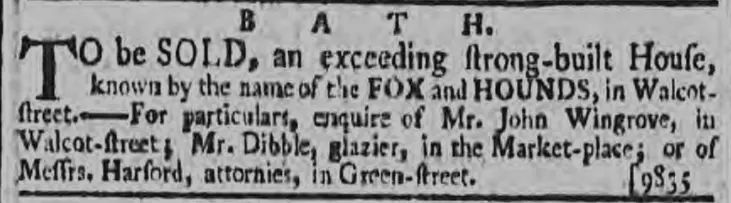
His son John Wingrove (1739 – 1790) ran the Marlborough Tavern, 35 Marlborough Buildings, Walcot, Bath and the Fox & Hounds, Walcot Street. He married Anne Blatchly (1740 1822) on 14 February 1764. They had six children in 11 years, but 4 died in infancy or childhood. His eldest son John (b 1765) became a ribbon weaver in Bristol.
Wingrove, Marlborough Tavern coach horses – Bath Chronicle and Weekly Gazette – Thursday 2 May 1793
John Wingrove, Fox and Hounds – Bath Chronicle and Weekly Gazette – Thursday 6 December 1787
The Curo cable car plan was abandoned after negative feedback during the consultation process. What I find interesting is why it was put forward? Did Curo really believe that it would receive planning permission in Bath’s World Heritage Site?
A quick review of this would have shown the obstacles that the Curo cable car plan would have faced in getting any planning approval. Presumably why they said they intended to bypass the usual planning system and go straight to the Secretary of State for Transport.
"Government guidance on protecting the Historic Environment and World Heritage is set out in National Planning Policy Framework and Circular 07/09. Policies to protect, promote, conserve and enhance World Heritage properties, their settings and buffer zones are also found in statutory planning documents. The Bath and North East Somerset Local Plan contains a core policy according to which the development which would harm the qualities justifying the inscription of the World Heritage property, or its setting, will not be permitted. The protection of the surrounding landscape of the property has been strengthened by adoption of a Supplementary Planning Document, and negotiations are progressing with regard to transferring the management of key areas of land from the Bath and North East Somerset Council to the National Trust."
Further reading would have shown:
"The site boundary is the municipal boundary of the city. This covers an area of approximately 29 square km. As noted in chapter 1, Bath is exceptional in this respect as the World Heritage inscription in almost every other city worldwide covers only a part of the urban area and not the entire settlement. Venice and its lagoon is the closest European comparator.

The property was inscribed in 1987 without a boundary map, which was not uncommon at that time. The description of the ‘City of Bath’ was taken to mean that the boundary encompassed the entire city and it was managed accordingly. This boundary was subsequently confirmed by letter (dated 17 October 2005) from the UNESCO World Heritage Centre."
and:
"Bath remains a compact city, contained largely within the hollow in the hills as previously described. The city does not have significant ‘urban sprawl’ and high quality built development directly adjoins high quality landscape at the urban edge. The skyline is predominantly characterised by trees or open pasture. The green hillsides provide a backdrop to the urban area and are visible from most of the city centre. Bath is well provided for in terms of parks and open spaces, with the River Avon cutting through the city centre providing natural beauty and sense of calm. All of the above contribute to an impression that the city is smaller than it actually is."
and:
"The Green Setting of the City in a Hollow in the Hills

42. The compact and sustainable form of the city contained within a hollow of the hills
43. The distinct pattern of settlements, Georgian houses and villas in the setting of the site, reflecting the layout and function of the Georgian city
44. Green, undeveloped hillsides within and surrounding the city
45. Trees, tree belts and woodlands predominantly on the skyline, lining the river and canal, and within parkland and gardens
46. Open agricultural landscape around the city edges, in particular grazing and land uses which reflect those carried out in the Georgian period
47. Fingers of green countryside which stretch right into the city"
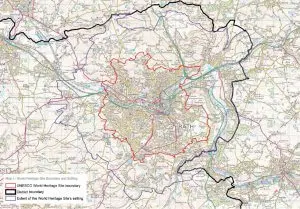
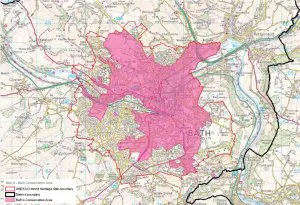
as well as various maps:
World Heritage Site extent
Green belt
Conservation area
So, why was the Curo cable care plan put forward? It would seem that it was most unlikely to get planning permission – unless there’s something I don’t know about.
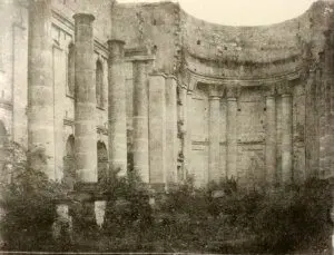
Unfinished Prior Park chapel in about 1855, Rev Francis Lockey (1796 – 1869)
I have spent some time adding to the galleries for Prior to Now and there are over 1,000 images of people, buildings and activities on Combe Down on the site.
Rev Lockey and his family lived in Swainswick near Bath, in a house known then as Swainswick Cottage and now known as the White House.
Amazingly Lockey’s photographic studio (now a conservatory) survives virtually intact at his former home. The studio has been confirmed as being the earliest known surviving photographic studio by the Science Museum.
Rev Lockey began experimenting in 1849, first using paper negatives and later glass plates developed using the calotype photographic process, which had been patented by William Henry Fox Talbot (1800 – 1877) in 1841.
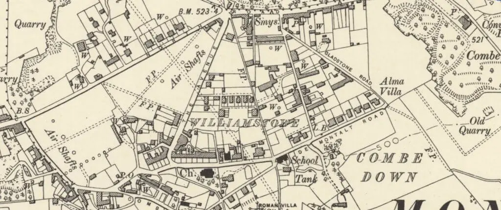
Central Combe Down in 1899 -Somerset, Revised 1899, Published 1904
As well as these galleries I have also added two maps. They are very large image files that take some seconds to download on even a fast connection but, once loaded and if all works as it should you can click on the image and zoom into it.
I have also added a section on Claremont Buildings or Hopecote Lodge as it is now known. It, along with Isabella Place and 109 – 117 Church Road, was part of the second wave of building on Combe Down from 1800. Some interesting people lived there including William Fortt who founded Fortt’s Refreshment Rooms in Milsom Street. Forrt’s later merged with tow other Bath firms to form Cater, Stoffell & Fortt that made the famous Bath Oliver biscuits.
which tells us that in 1870 – 72, John Marius Wilson’s Imperial Gazetteer of England and Wales described Combe Down like this:
“COMBE-DOWN, a chapelry in Combe-Monckton parish, Somerset; near the Great Western railway and the river Avon, 2 miles S of Bath. It has a post office‡ under Bath. Pop., 940. A hill, giving name to the place, is 550 feet high; commands an extensive prospect; yields Bath stone in large quarries; is pierced and cut with caverns and passages; and bears on its slope a pleasant little town, with villas, an inn, and the church. The living is a vicarage in the diocese of Bath and Wells. Value, not reported.* Patron, the Vicar of South Stoke“.
Historical maps
There’s also a link to historical maps that you can see, often, as a seamless map overlaying the modern equivalent and/or download the original free.
Historical map of Combe Down
There are general purpose topographic historical maps:
I was just looking at the Hunt & Co. and Silverthorne directories for Bath and Bristol for 1848 and 1846 respectively and thought it would be interesting to see what went on in the village around then – what was it like on Combe Down around 1846 – 1848? Who is mentioned? What trades and professions?
The problem is that, unlike later Kelly’s directories that locate a place and then show the people living there plus their occupations etc. these earlier directories are alphabetical and by class, so it’s not so simple to get an idea of what was going on.
Luckily, in this age of the internet you can find ‘electronic’ copies of most things, which makes it easier to do a search and then……
The results are below and provide an interesting snapshot of some of the people who lived and worked here.
I find a number of things interesting, compared to today.
For example the use of ‘nobility and gentry’ and people describing themselves as ‘gent’.
The boarding and day schools situated in private houses.
The fact that there were actually shops in the village (!) – no cars or supermarkets then.
Additionally, given the total population of 1,600 – 1,750 there are, unlike say the old telephone directories, actually very few people listed.
One other thing is the blacksmith. In Silverthorne’s of 1846 it is George Humphries but by Hunt & Co of 1848 it is Harriett Humphries – presumably his wife or daughter. But, was she the owner or did she actually smith? It would be interesting to know.
The census’ for 1841 and 1851 also give a picture and are shown below the directory findings.
Some interesting things were going on with property on Combe Down around this time.
John Ovens Thomas (1778 – 1836), the eldest son of John Thomas, the owner of Prior Park had died 10 years earlier but in 1846 his trustees decided to sell much of the land he had inherited from his father as well as some of his ground rents. The land, as can be seen from the estate sale notice below included the farm next door to St. Michael and All Angels Church at Monkton Combe, a number of fields near the Dundas Acqueduct and Midford Brook as well as ground rents for the Tyning Road area, The Brow, and Tyning Place.
John Ovens Thomas estate sale – Bath Chronicle and Weekly Gazette – Thursday 16 April 1846
It also included the land from North Road to Church Road as the map below shows, The map also gives a really good idea of what this area of Combe Down was like in 1846.
Map of Combe Down plots for sale from estate of John Oven Thomas in 1846
Hunts & Co 1848
Nobility, Gentry, &c.
Baskett Mrs. Sarah, 6, De Montalt place, Combe down
Payne John, overseer of the parish of Monkton Combe, Park villa, Combe down
Radburn George, quarry master, Combe down
Rawlings William, Carriage Inn, Combe down
Ricketts Charles, carpenter & joiner, Combe down
Salter Job, 1, Priory cottages, Combe down
Spence Samuel, Hadley Arms, and quarry master, Combe down
Stinnard & Ford, quarry masters, Combe down
Stodart John, 2, Claremout buildings, Combe down
Sumsion Isaac, quarry master, 1, Park place, Combe down
Vincent William, boot & shoe maker, 9, Cheap street — p. r. Combe down
Whitaker William, boot and shoe maker, Combe down
Wren Thomas Jay, short hand writer, and stationer, Combe down
Churches
Trinity, Combe down. — Sunday, 11 morn. and 6 even. Sacrament administered the first Sunday in the month. Rector, Rev. George Newnham. Curate, -Rev. D. Topham.
Just seeing what an area looked like 100 or more years ago on and Ordnance Survey map can give real insights into the place.
Of course very old maps tend to be either somewhat inaccurate or have little detailed data because of their scale.
Even so they can be interesting and the history of the maps themselves is almost as fascinating.
As most people know the mapping of the British Isles has been led by the Ordnance Survey, which was, effectively, started after the Jacobite rising of 1745.
In 1747, Lieutenant Colonel David Watson proposed a map of the Highlands to subjugate the clans.
King George II charged Watson with making a military survey of the Highlands under the command of the Duke of Cumberland.
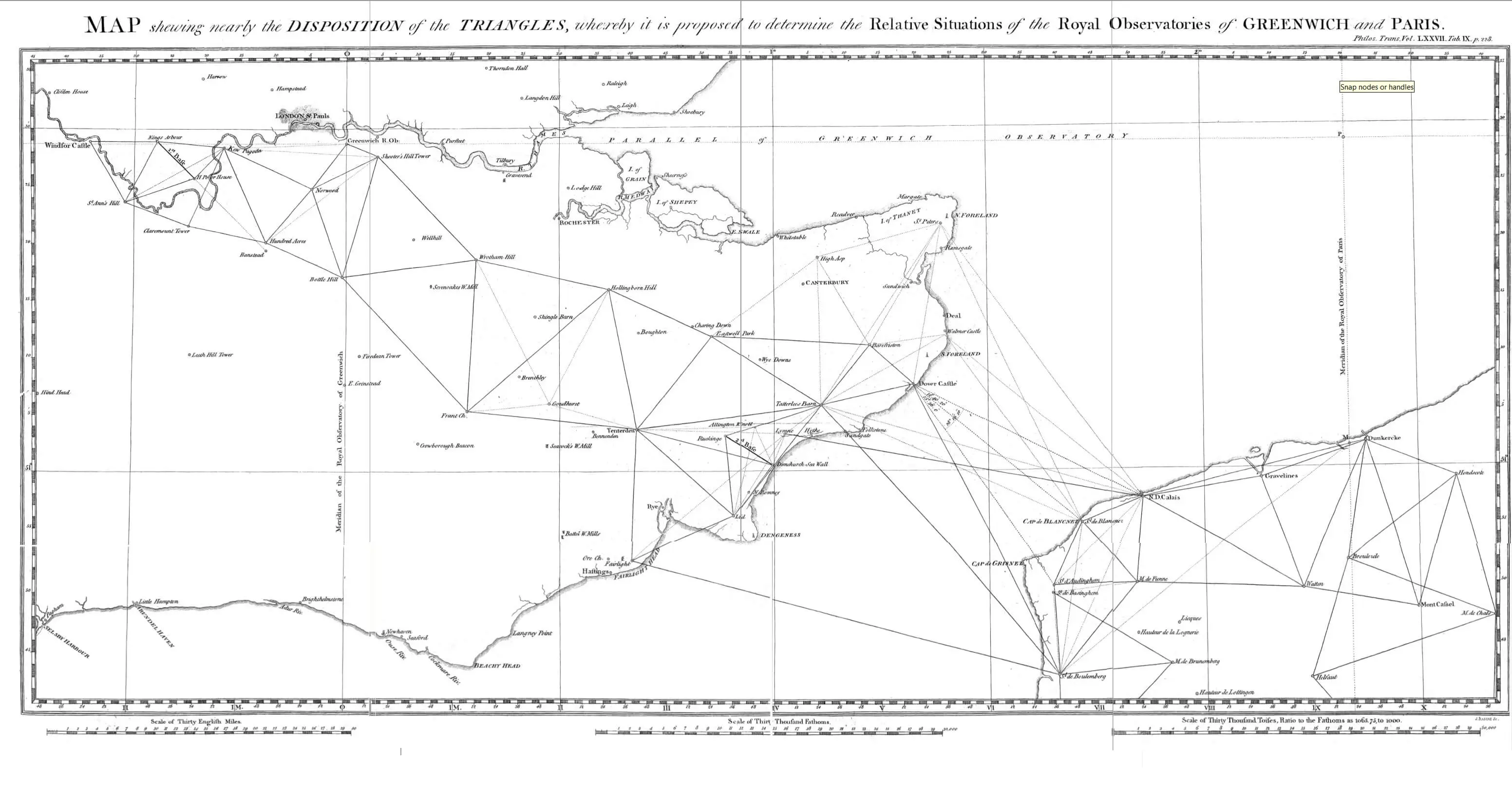
This eventually led to the Principal Triangulation of Great Britain (1783–1853), a project carried out between 1784 and about 1853 at the instigation of senior surveyor General William Roy (1726–1790) and to the creation of the Ordnance Survey.
Anglo French survey of 1784-1790 proposed mesh by William Roy – Scanned from Philosophical Transactions of the Royal Society of London vol77: 188–226 1787
In 1801, the first one-inch-to-the-mile (1:63,360 scale) map of Kent was published.
During the next twenty years, roughly a third of England and Wales was mapped at the same scale under the direction of William Mudge (1762 – 1820).
Somerset was mapped by 1817. It was tough work, Major Thomas Colby (1784 – 1852) walked 586 miles in 22 days in 1819.
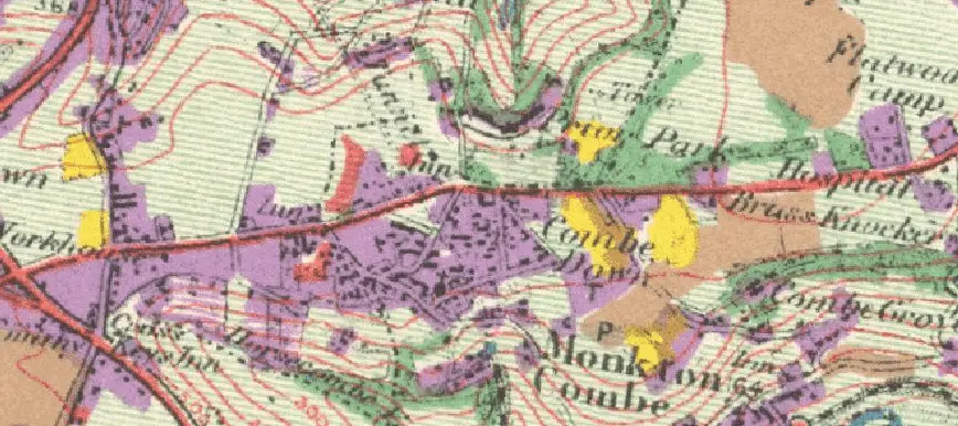
The map of that covers Combe Down, that was published in 1817, shows surprisingly little change has occurred . Development of housing , yes, but the shape and the main features are very recognizable.
Combe Down Ordnance Survey first series 1817
This work is based on data provided through www.VisionofBritain.org.uk and uses historical material which is copyright of the Great Britain Historical GIS Project and the University of Portsmouth.
I just love old handbills and maps. Bath Record Office has a small treasure trove of them.
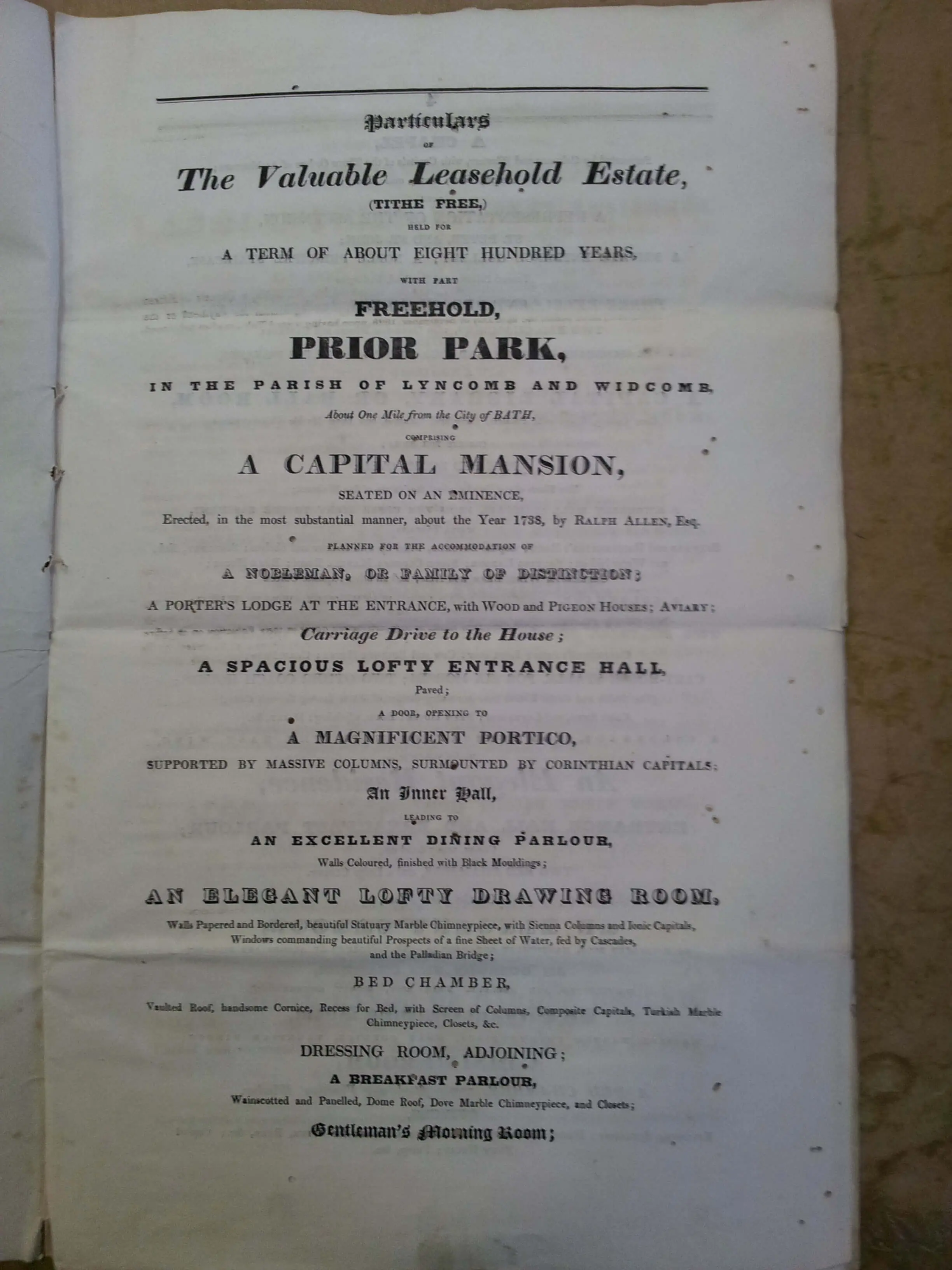
Here are some prepared for the Prior Park sale in 1808 before John Thomas bought in in 1809.
The language is wonderful. “A capital mansion, seated on an eminence, erected, in the most substantial manner, about the Year 1738, by RALPH ALLEN, Esq. Planned for the accommodation of A NOBLEMAN, OR FAY OF DISTINCTION”.
If one had the wherewithal it would be difficult to resist. It’s a world away from the ‘estate agent speak’ we are so used to; but then, so is the property.
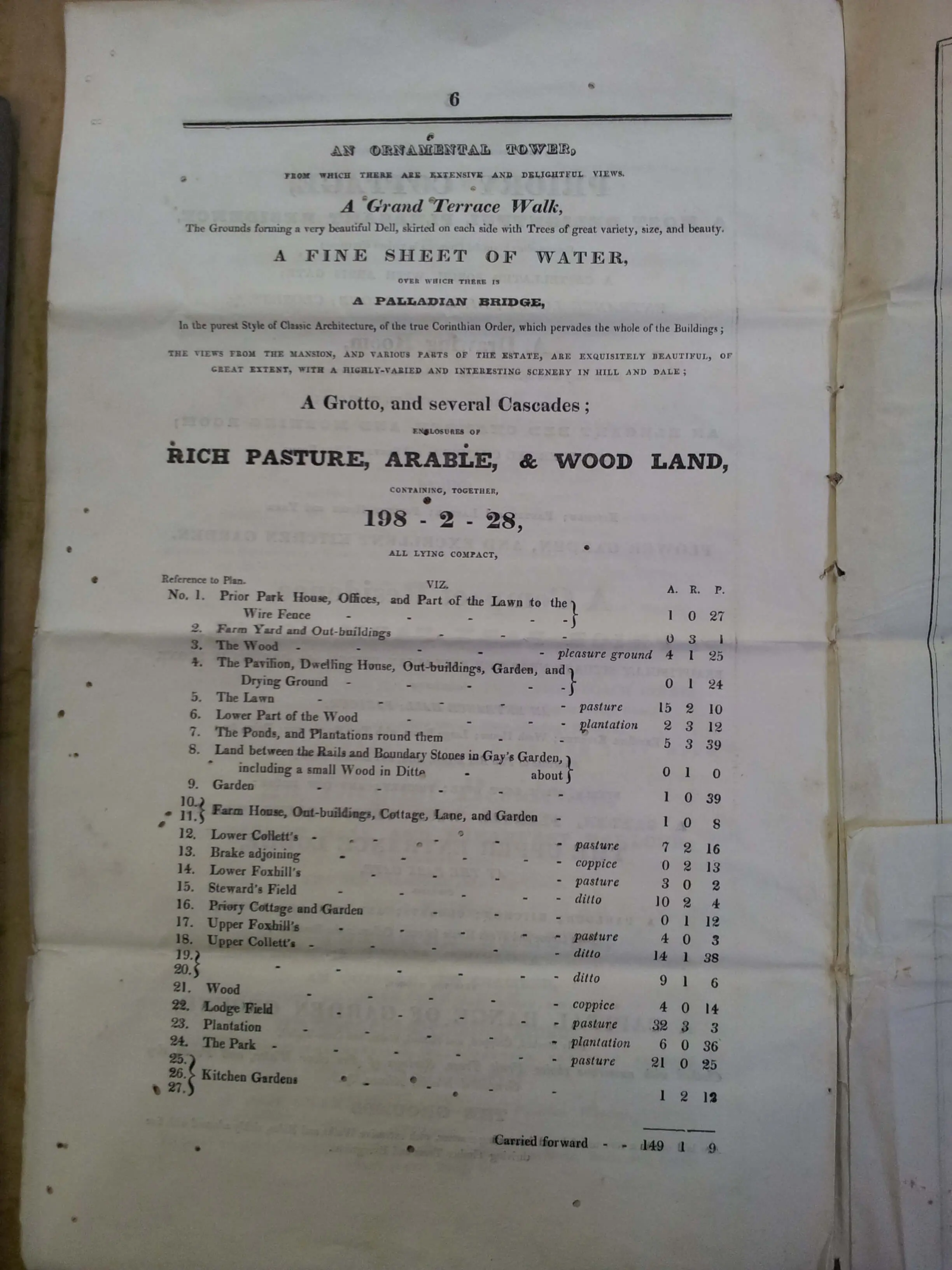
Anyone wondering what A, R, and P are was obviously born more recently! It’s acres, roods and perches.
Front of sale particulars for Prior Park in 1808
More details of sale particulars for Prior Park in 1808
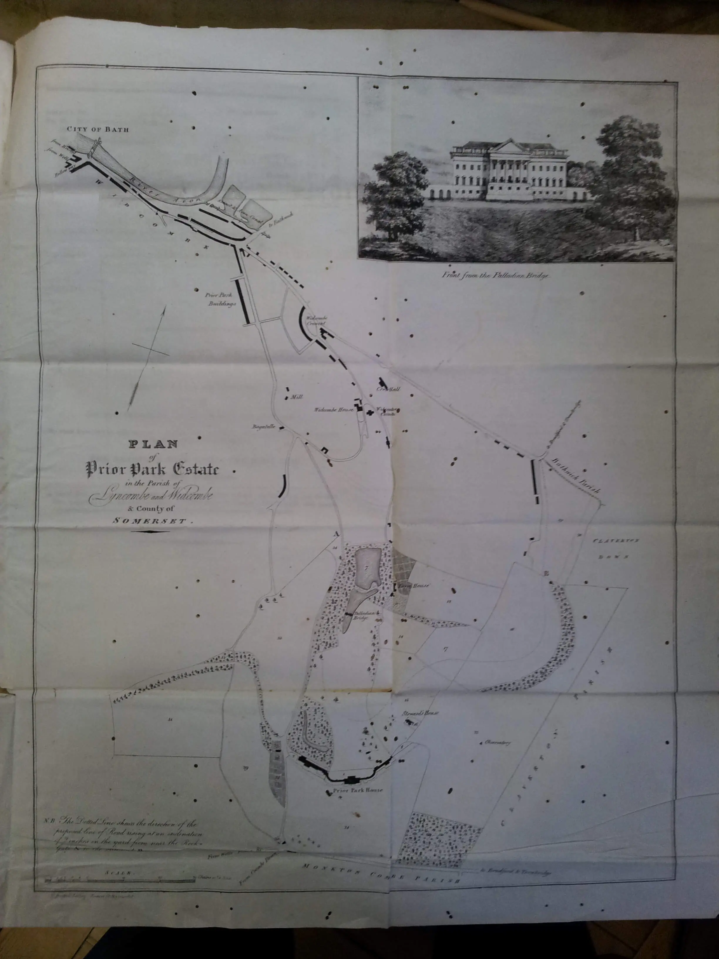
Map details of sale particulars for Prior Park in 1808
To provide the best experiences, we use technologies like cookies to store and/or access device information. Consenting to these technologies will allow us to process data such as browsing behavior or unique IDs on this site. Not consenting or withdrawing consent, may adversely affect certain features and functions.
Functional
Always active
The technical storage or access is strictly necessary for the legitimate purpose of enabling the use of a specific service explicitly requested by the subscriber or user, or for the sole purpose of carrying out the transmission of a communication over an electronic communications network.
Preferences
The technical storage or access is necessary for the legitimate purpose of storing preferences that are not requested by the subscriber or user.
Statistics
The technical storage or access that is used exclusively for statistical purposes.The technical storage or access that is used exclusively for anonymous statistical purposes. Without a subpoena, voluntary compliance on the part of your Internet Service Provider, or additional records from a third party, information stored or retrieved for this purpose alone cannot usually be used to identify you.
Marketing
The technical storage or access is required to create user profiles to send advertising, or to track the user on a website or across several websites for similar marketing purposes.