I’ve found an historical maps treasure trove. There’s a lovely page at:
A Vision of Britain through Time
History of Combe Down in Bath and North East Somerset.
which tells us that in 1870 – 72, John Marius Wilson’s Imperial Gazetteer of England and Wales described Combe Down like this:
“COMBE-DOWN, a chapelry in Combe-Monckton parish, Somerset; near the Great Western railway and the river Avon, 2 miles S of Bath. It has a post office‡ under Bath. Pop., 940. A hill, giving name to the place, is 550 feet high; commands an extensive prospect; yields Bath stone in large quarries; is pierced and cut with caverns and passages; and bears on its slope a pleasant little town, with villas, an inn, and the church. The living is a vicarage in the diocese of Bath and Wells. Value, not reported.* Patron, the Vicar of South Stoke“.
Historical maps
There’s also a link to historical maps that you can see, often, as a seamless map overlaying the modern equivalent and/or download the original free.
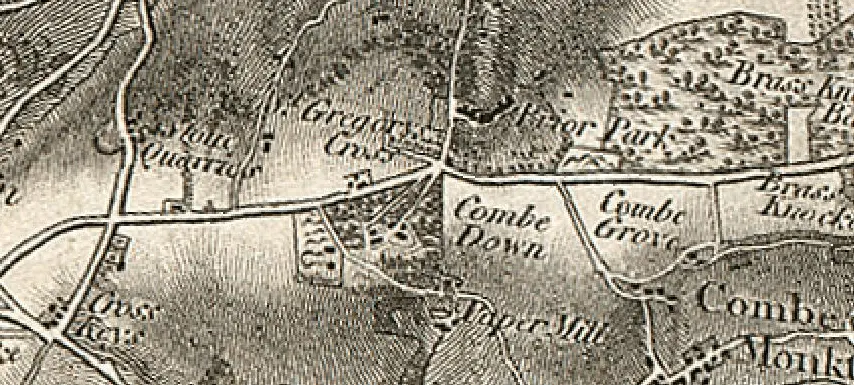
There are general purpose topographic historical maps:
- Ordnance Survey First Series 1:63360
170 sheets covering England and Wales, 1805 to 1869 - C. Smith New Map of Great Britain and Ireland 1:633600
4 sheets covering Great Britain, 1806 - R. Wilkinson The British Isles 1:2000000
1 sheet covering Great Britain, 1812 - Ordnance Survey of Scotland First Series 1:63360
130 sheets covering Scotland, 1856 to 1887 - Ordnance Survey of England and Wales Revised New Series 1:253440
19 sheets covering England and Wales, 1902 to 1905 - Ordnance Survey of Great Britain New Series 1:633600
8 sheets covering Great Britain, 1904 - British War Office GSGS 4127 1:126720
25 sheets covering Ireland, 1916 to 1941 - Ordnance Survey of Scotland Popular Edition 1:63360
91 sheets covering Scotland, 1925 to 1948 - British War Office GSGS 4072, 4140, 4369 1:500000
119 sheets covering Europe, 1940 to 1950 - Ordnance Survey of Great Britain New Popular Edition 1:63360
114 sheets covering England and Wales, 1945 to 1948 - British War Office AMS 1202, GSGS 2957 1:4000000
3 sheets covering Europe, 1957 to 1958
as well as boundary historical maps showing administrative boundaries, for counties, districts, parishes etc.:
- Ordnance Survey Unions
80 sheets covering England and Wales, 1803 to 1840 - H.M.S.O. Boundary Commission Report 1832
304 sheets covering England and Wales, 1832 - H.M.S.O. Boundary Commission Report 1868
261 sheets covering England and Wales, 1868 - Ordnance Survey County Boundaries
56 sheets covering England and Wales, 1870 to 1899 - H.M.S.O. Boundary Commission Report 1885
100 sheets covering England and Wales, 1885 - Ordnance Survey Sanitary Districts, showing Civil Parishes
54 sheets covering England and Wales, 1888 - Ordnance Survey Index Sheets of England and Wales showing Civil Parishes
26 sheets covering England and Wales, 1888 to 1912 - Ordnance Survey Maps of England and Wales
55 sheets covering England and Wales, 1900 - H.M.S.O. Boundary Commission Report 1917
81 sheets covering Great Britain, 1917 - Ordnance Survey County Diagrams of England and Wales
57 sheets covering England and Wales, 1920 to 1929 - Ordnance Survey County Divisions of England and Wales
57 sheets covering England and Wales, 1922 to 1928 - Ordnance Survey Maps of England and Wales – Revised
57 sheets covering England and Wales, 1931 to 1944 - Ordnance Survey Miscellaneous Boundary Maps
26 sheets covering England and Wales, from 1949
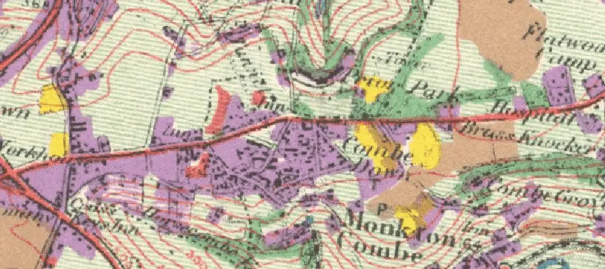
as well as land use historical maps recording what each plot of land was being used for on the day it was surveyed, in the 1930s:
- Geographical Publications Limited Land Utilisation Survey of Britain 1:63360
168 sheets covering Great Britain, 1925 to 1948 - Unpublished Land Utilisation Survey of Britain 1:63360
56 sheets covering Great Britain, 1925 to 1948 - Geographical Publications Limited Land Utilisation Survey of Britain 1:633600
2 sheets covering Great Britain, 1942